Jason Boroughs is Mount Vernon’s research archaeologist. With nearly three decades of experience excavating historical sites throughout America and the Caribbean, his research and publications focus on plantation communities in the Chesapeake Bay region.
Above image: An 1801 commemorative version of Washington’s original 1793 survey of Mount Vernon’s five farms.
Archaeologists search for clues to the other working farms that were once part of George Washington’s estate
Each day, visitors to Mount Vernon experience the nation’s longest running endeavor in historic preservation as they explore its well-preserved grounds and meticulously restored 18th-century structures. Yet many people never realize that the 400-plus-acre estate painstakingly restored and maintained by the Mount Vernon Ladies’ Association was but one of five farms spanning approximately 8,000 acres that comprised George Washington’s Mount Vernon at the end of his life in 1799. Mansion House Farm was complemented by four adjacent “working” farms—Dogue Run, Muddy Hole, Union, and River Farms. Although much of the 12 square miles encompassed by Mount Vernon’s five farms has been developed, fragments of the original Washington-period landscapes lie hidden in plain sight amidst the modern fabric of suburban northern Virginia. Using proven archaeological techniques and innovative technologies, Mount Vernon archaeologists continue to uncover new aspects of Washington’s world.
An Estate in the Making
In many ways, Washington viewed the development of his estate as a generational family endeavor, a legacy in which he immersed himself enthusiastically. The tenure of the Washington family on the lands that would become Mount Vernon began with a royal land patent in 1674 of 5,000 acres between Dogue Run and Little Hunting Creek, granted to Col. Nicholas Spencer and Lt. Col. John Washington, George Washington’s great-grandfather. Spencer and the elder Washington divided the parcel in two, with the Spencers taking the western lands along Dogue Run and the Washingtons occupying the eastern half along Little Hunting Creek. Mount Vernon was originally called Little Hunting Creek Plantation, until it was renamed by Lawrence Washington, George’s older half-brother, who inherited the property in 1743. After Lawrence’s passing, George leased the property from his sister-in-law, Lawrence’s widow, Anne Fairfax Washington Lee, until he inherited the estate outright at her death in 1761. Thus began a three-and-a-half-decade-long quest by George Washington to purchase the patchwork of small plantations along Dogue Creek that had splintered from the original Spencer tract, with the intent of reconsolidating the lands that comprised the original 5,000-acre patent and expand upon his ancestral holdings. With the last acquisition in 1786, all the pieces were back in place and Washington set about centralizing agricultural operations and strengthening infrastructure across the five farms.
On the morning of December 12, 1799, George Washington set out on horseback from Mansion House Farm on what would ultimately become his final ride. In foul weather, he spent the better part of a day traveling a circuit of his farms to oversee operations. The next morning the weather had taken its toll, exacerbating a severe throat inflammation to which Washington eventually succumbed. His final ride is a well-documented historical episode for obvious reasons, yet it also holds clues about the layout and organization of Mount Vernon’s farms. That the General was able to travel a complete circuit across a 12-square-mile estate in a manner of hours, with time spent at each of the outlying farms—one of which required crossing a tidal creek—suggests that Mount Vernon had a well-designed infrastructure in good repair. A map of Mount Vernon’s farms surveyed and drafted by Washington himself in 1793 details the estate’s infrastructure and offers a unique window into the landscapes of Washington’s agricultural enterprise.
A Vision for American Agriculture
Washington was an early proponent of emerging scientific agricultural practices. His intent was that Mount Vernon could serve as a model for his vision of a new American agriculture. He experimented with and pioneered new soil enrichment techniques and developed seven-year crop rotation schedules for each of his farms. To implement these new practices, he had ravines filled and designated new agricultural fields, enclosing them with boundary ditches and new fence lines. At Union Farm, so named because it was the union of several farms that had been independent plantations prior to 1786, Washington ordered the quarters for enslaved agricultural workers relocated to the center of the consolidated farm. He designed a sophisticated brick barn and stabling facility with access to the new fields to make use of animal manure for soil enrichment. On an insurance policy dated a few years after his death in 1805, the barn was assessed at more than half the value of the Mansion, making it the second most valuable structure on the estate. A broad plantation lane connected the domestic quarter with the barn. Washington was meticulous in his designs, and each of these activities—brought to fruition by the hands of enslaved laborers—left enduring traces on the landscape.
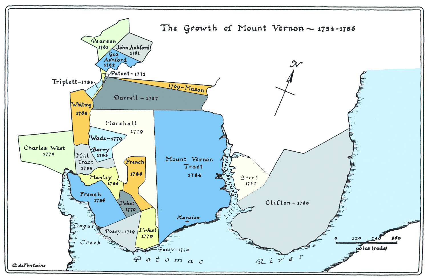

The illustration (above) shows land purchases by George Washington between 1754 and 1786.
A scale overlay of Washington’s 1793 survey of Mount Vernon on modern aerial imagery (left) depicts the five farms shaded in blue with plantation roads marked in red.
Rediscovering Washington’s Farms
So, what survives of Mount Vernon’s farms in the midst of suburban expansion? And how do archaeologists go about finding what remains?
Historical documents, such as Washington’s 1793 survey, provide starting points for archaeological research. Many traditional excavation methods have essentially remained unchanged for the better part of a century. Archaeologists still dig square holes and sift soils to recover artifacts. But new noninvasive (i.e., non-digging) technologies allow researchers to discover and zero in on areas of interest below ground and to search broader areas of land and less accessible terrain with expedient aerial techniques. Whether at ground level or from a bird’s-eye view, these technologies allow for the rediscovery of large-scale landscape features such as roads, field and parcel boundaries, and traces of 18th-century domestic landscapes that might otherwise remain hidden.
Over the past quarter century, archaeologists worldwide have adapted the same technology that powers smartphone navigation programs to map ancient landscapes and guide archaeological excavations. At Mount Vernon, GIS (geographic information system) technology is being used to overlay historical maps, such as Washington’s 1793 survey, onto the modern landscape, using the reference of the Potomac shoreline and tributaries to search for sections of Washington’s estate that may have escaped suburban development.
Mount Vernon’s archaeologists are using GIS in conjunction with LiDAR (light detecting and ranging), a technique that uses quick-firing lasers to measure distances. The technology can be used to make incredibly accurate three-dimensional topographic models of the ground surface when operated from a low-flying aircraft. In forested areas, trees may obstruct the line of fire, but because the lasers pulse in rapid bursts and the aircraft is moving, the beams typically reach the ground surface. Software can then effectively filter out the trees, allowing for rapid and large-scale survey of forested areas that would otherwise remain inaccessible.
The Mount Vernon Ladies’ Association commissioned an aerial LiDAR survey of Mount Vernon’s five farms in 2015. When the data were input in GIS as an overlay with Washington’s 1793 survey and modern aerial imagery, the results were extraordinarily revealing. Linear furrows that may have been cut by 18th-century plows reemerged under the lush grass of the 12-acre field facing the Mansion. The intriguing suggestion is that even today, within densely developed areas, intact archaeological resources from the Washington period survive on the former grounds of each of Mount Vernon’s farms. In areas reclaimed by modern forest, ditches that once marked the boundaries of agricultural fields at Dogue Run became visible once more. At Union Farm, sections of the plantation lane that connected the quarter for enslaved agricultural workers with the brick barn were easily identifiable, as was the remnant of a well in the center of the quarter in the exact location that Washington directed one be placed in a series of letters to his farm manager in 1793–1794. The data are currently guiding archaeological excavations of the Union Farm quarter. Much of the LiDAR data is still being analyzed, with the expectation that more fragments of Washington’s five farms will be identified.
Archaeologists have experimented with another high-tech device at Mount Vernon—a GPR (ground penetrating radar) unit—that enables one to “see” beneath the ground surface without putting shovel to soil. This powerful tool has the capability to reveal buried archaeological features and explore hidden landscapes in a rapid and noninvasive manner, assisting researchers in targeting certain features or areas for excavation while marking others for continued preservation.
Combining tried and true archaeological and historical methods, contemporary detective work, and innovative digital technologies, Mount Vernon’s archaeologists continue to identify and explore surviving fragments of the Mount Vernon estate to paint a clearer picture of Washington’s world.

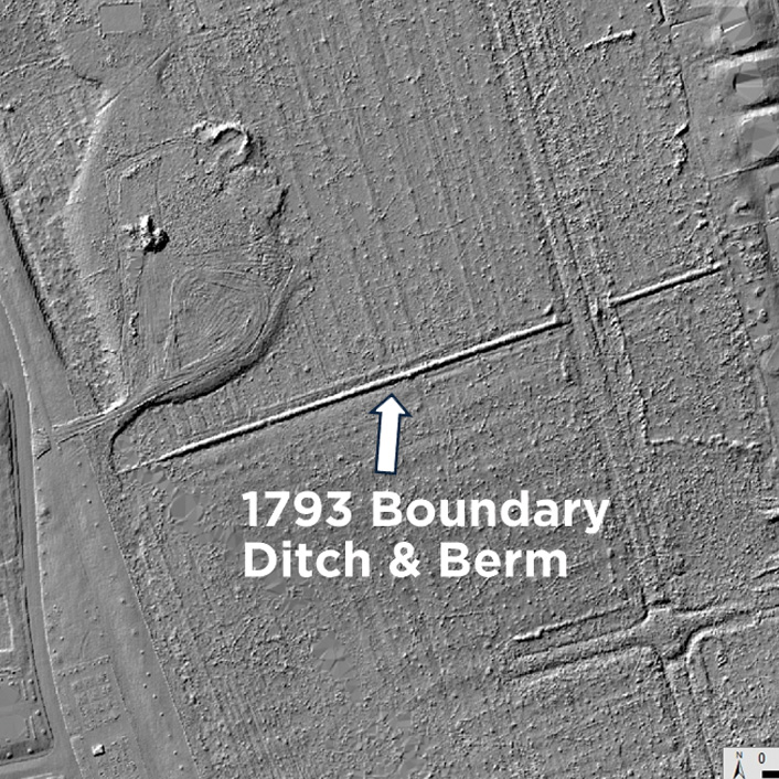

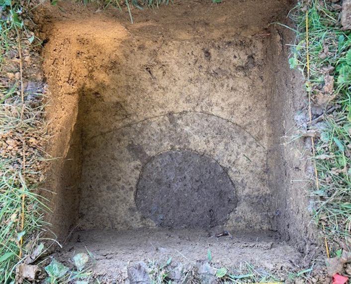
Mount Vernon’s archaeologists use high-tech and low-tech methods to find hidden Washington-period landscapes amongst northern Virginia’s suburban sprawl. Overlaying Washington’s 1793 map on both aerial imagery (opposite left) and digital models of the ground surface produced with LiDAR technology (opposite right) led to the discovery in a forested area between modern developments of a section of ditch-and-berm earthwork that once marked the boundary between fields at Dogue Run. The same technique was used to identify segments of a 1790s plantation road and well at Union Farm (above) on a parcel of land adjacent to a modern golf course. At ground level, archaeologists exposed the remnants of a timber post (dark circle), likely part of an outbuilding, animal enclosure, or fence line constructed by Union Farm’s enslaved residents.
Think Like an Archaeologist
Archaeology is hyper-local history. Archaeologists make inferences about past peoples through the objects left behind, but they also note the context and the manner of an artifact’s deposition to determine the types of activities that occurred in a given location. Animal bones recovered at Mount Vernon, for instance, reveal much about the diet and provisioning patterns of the people who lived and worked on the estate. But how and where the bones were discarded can also help identify where butchery activities took place, and by whom.
The ways in which the landscape has been shaped by human hands over time reveal much about the lives of the people who touched it. Soil layers and enduring modifications to the land, or features, are often described as nonportable artifacts. A brick foundation, a well shaft, and a human grave are examples of archaeological features, as are ditches and trash pits, brick hearths, and remnants of timber posts that once formed fence lines, animal enclosures, or framing supports for a variety of dwellings and structures. All are fairly common finds at sites like Mount Vernon.
For example, a layer of bright-red clay discovered in archaeological test pits spread out across the lawn near the Mansion’s piazza made little sense until archaeologists conducted excavations in the cellar (in advance of structural repairs) and discovered the source of the clay. It was likely removed from the cellar as the Washingtons expanded the Mansion’s footprint in the 1770s. The clay excavated from the new cellar addition was used to shape the knolls on the riverfront side of the Mansion. George Washington engineered several such eye-catching “vistos” of the Mansion from different points of view to impress upon visitors the magnitude of the domestic seat of Mount Vernon as they approached. Reshaping the knolls increased the prominence of the Mansion from lower angles and framed the view of the Potomac River basin from the piazza, a view that contemporary visitors enjoy to this day.
Discover more about archaeology at Mount Vernon at mountvernon.org/archaeology.